Climate Data
January 2020 Weather Summary for Belize
January 2020 started off uncharacteristically fair, warm and mostly dry as a light to moderate East to southeasterly airflow dominated the area. A frontal system reached as far as northern Yucatan then gradually retreated over the Gulf of Mexico by nightfall on the first day of the New Year. Weather conditions remained fair with little or no rainfall from the 2nd to the 3rd.A moderate to gusty North to northwesterly flow prevailed on the 4th along with layered clouds as a cold front crossed the country. Light rain affected mainly the Belmopan area during the frontal passage. Skies remained cloudy to overcast and winds gusty and from the north to northwest on the 5th with light showers or rain mostly over coastal waters.
Cloudy skies continued to dominate most of the country from the 6th to the 8th with light rain occurring mainly offshore at first then showers and periods of rain affected central areas on the 8th as a gusty East to Northeast flow prevailed due to a surface trough over the western Caribbean Sea. As the trough moved closer to the coast of Central America conditions became even moister and unstable on the 9th resulting in showers and thunderstorms especially over northern and central areas. By the 10th a strong ridge of high pressure dominated the Caribbean basin and a moderate to gusty East-southeasterly airflow prevailed which supported mostly isolated showers across the country.
The strong high-pressure ridge continued to dominate over the next few days from the 11th through to 15th and maintained a gusty East to southeast flow on the 11th with only isolated showers developing. From the 12th to the 15th gusty east to northeast winds prevailed and showers affected mostly northern and central areas on the 12th and 13th but spread to most areas on the night of the 13th then affected mainly central and southern coastal areas on the 14th and 15th. A few showers and periods of rain continued to affect southern and central portions of the country on the 16th as a weak surface trough developed over the western Caribbean Sea. This activity increased overnight especially over the south where some showers and a few thunderstorms developed along with rough seas. Conditions remained moist and unstable on the 17th with shower and thunderstorm activity increasing and spreading to most areas with the heavier showers affecting southern districts. The highest rainfall was recorded in Dangriga where almost an inch and a half of rainfall fell in a six-hour period. A few showers continued across the country on the 18th then the activity became isolated during the night and on the 19th.
Moisture and winds started to increase once more over the area on the 20th with the approach of another cold front. This supported the development of a line of moderate showers that moved primarily over northern and central areas of the country overnight. A ridge of high pressure dominated during the next couple of days from the 21st to the 22nd in the wake of the cold front and supported variably cloudy, cool and mostly dry conditions over the country with no significant rainfall.Generally fair weather with only isolated showers prevailed from the 23rd to the 25th as a light East to northeasterly airflow dominated the area. From the 26th to the 29th conditions remained fair but became even drier as an East to southeasterly airflow prevailed.
The last two days of the month weather conditions continued mainly fair and mostly dry from the 30th to the 31st with the exception of only isolated showers over the western edge of the Maya Mountains during the night of the 31st.
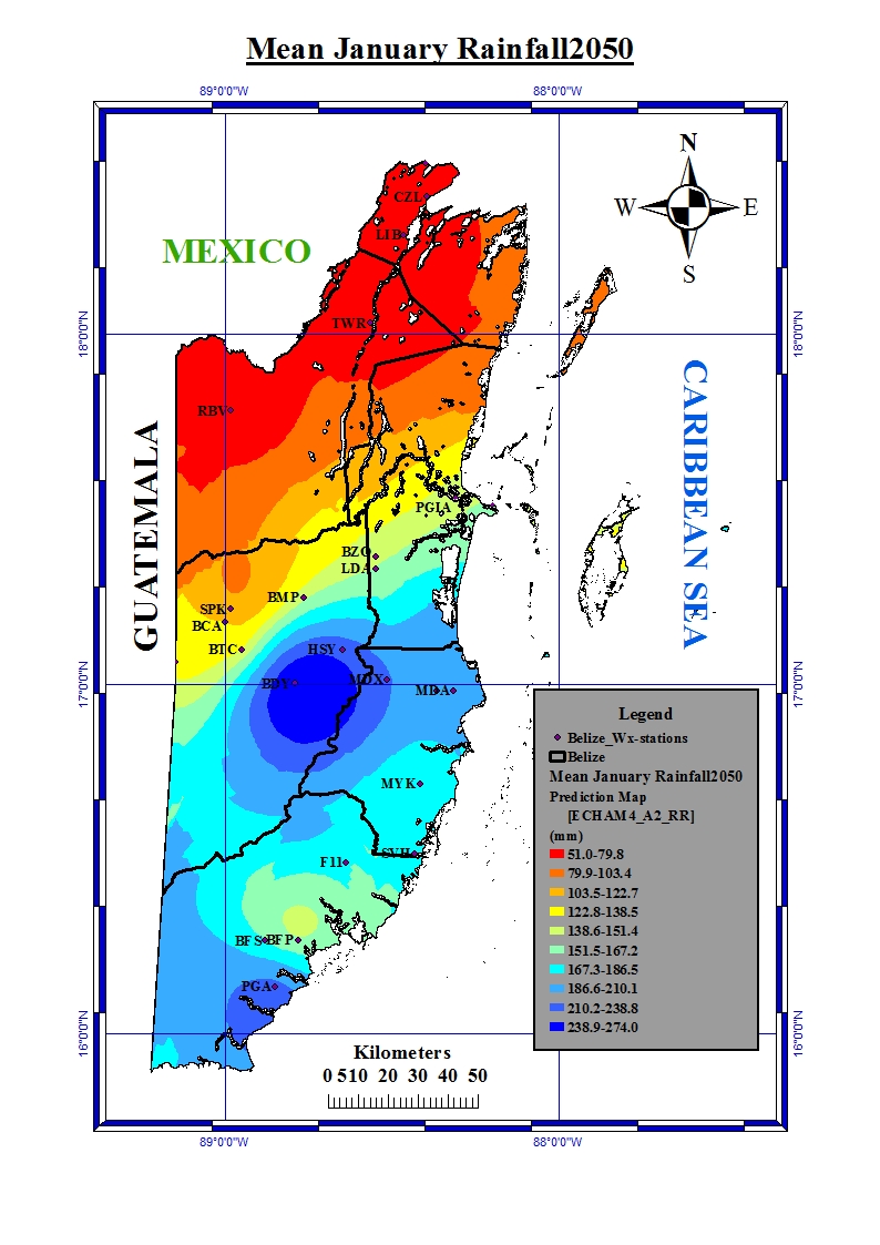
Rainfall for Belize in the year 2050
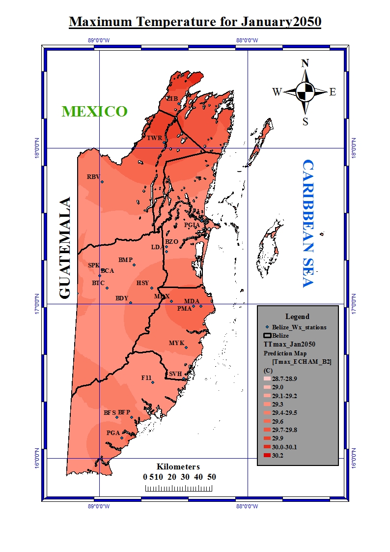
Maximum temperature for Belize in the year 2050
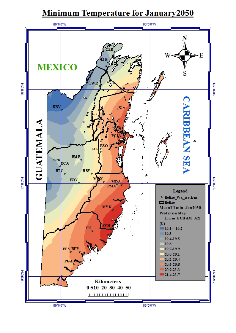
Minimum temperature for Belize in the year 2050
.